Objectives and science questions
The overall objective of this new activity, the Land surface Interactions with the Atmosphere over the Iberian Semi-arid Environment (LIAISE) project, is to improve our understanding of the impact of anthropization on the water cycle in terms of land-atmosphere-hydrology interactions, and the limitations of models to represent all aspects of the terrestrial water cycle in a semi-arid environment on the Iberian peninsula. The main science questions can be summarized as:
- What are the key natural and anthropogenic semi-arid surface processes that modulate or control infiltration and runoff and govern turbulent fluxes and their spatial heterogeneity?
- How does anthropization impact boundary layer development, mesoscale circulations and potentially precipitation recycling over this region via feedbacks with the atmosphere?
- What is the sustainability of ground water and reservoirs in the face of expanding agricultural and farming activities, especially in light of projected future warming and drying over this region?
LIAISE addresses the GEWEX Science Questions and contributes to WCRP’s Grand Challenges, notably how a warming world will affect available fresh water resources globally, specifically in the food basket regions, and how it will change human interactions with these resources and their value to society. Another key GEWEX Science Question addressed by LIAISE pertains to improving our understanding of the effects and uncertainties of water and energy exchanges in the current and changing climate and how to convey this information to society. The improvement of the representation of anthropogenic effects in models will form the foundation for water resource impact studies under future climate change. These results will be communicated to water management services within the Ebro basin. A comprehensive database, consisting of surface-based and aircraft measurements of surface and hydrological fluxes and states and properties of the ABL, will be integrated into the Mediterranean Integrated STudies at Regional And Local Scales (MISTRALS)/HyMeX database, which can accessed upon request by interested researchers. This database of observations will form the basis for a number of international modeling experiments that will cut across many areas of interest to GEWEX, ranging from theability of LSMs to capture soil moisture dry down, the representation of heterogeneity and how this interacts with the atmospheric boundary layer, the impacts of human influence on land surface fluxes, land/atmosphere interactions the terrestrial water cycle of semi-arid environments.
Field campaign
This is the last field campaign of the HyMeX project, and is a core activity leading into HyMeX phase 2. The study domain for LIAISE is the Ebro basin in northeastern Spain, which is bound to the north by the Pyrenees and to the south by the Iberian System. Surface heterogeneity has grown due to the presence of human society, which has been altering the hydrological cycle and the landscape mainly through intense agricultural activity. There are 2 observation periods :
1) Intensive Observation Period (IOP): April through September 2021
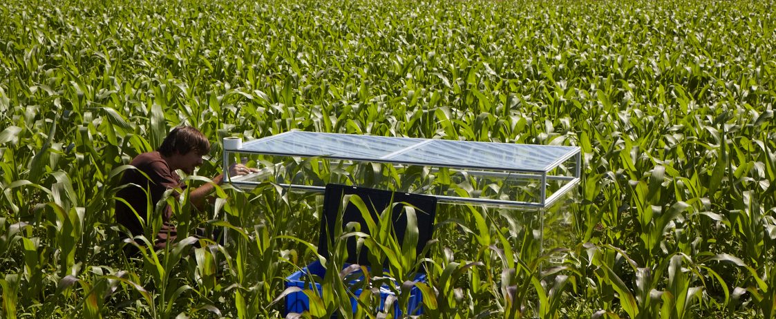
A network of surface energy budget (SEB) observing stations will be installed within an approximately 10 km radius centered over the Urgell and Plà d’Urgell (Lleida) region of the Ebro basin. This area is selected since it encompasses multiple representative Mediterranean land cover types, including a small lake. This location will also allow us to benefit from the dense local meteorological station and radar data from the Spanish State Meteorological Agency (AEMET) and the Meteorological Service of Catalonia (SMC), along with an existing extensive observation site run by the Institute of Agrifood Research and Technology (IRTA), which includes weighing lysimeters. This network will enable us to evaluate the ability of land surface models (LSMs) to simulate fluxes, especially evapotranspiration, over irrigated sites and to contrast the fluxes with those from natural surfaces. These sites will be maintained at least through entire growing season. State-of-the-art soil moisture products [such as that from the Soil Moisture and Ocean Salinity (SMOS) and Soil Moisture Active Passive (SMAP) missions] will be combined with in situ soil moisture observations from an existing network in collaboration with the Ebro Observatory and private irrigation-monitoring companies for use in assimilation into the LSMs and/or for evaluation. Field-scale actual and potential evapotranspiration will be evaluated using two-source energy balance (TSEB) models, which combine thermal observations from Sentinel-3 satellites and optical observations from Sentinel-2 satellites.
2) Special Observation Period (SOP): July, 2021
The SOP is planned for July, when contrasts between irrigated and natural surfaces are at their maximum. The SEB stations will be complimented by additional biogeophysical measurements and trublence estimates, such as those from scintillometers. The SEB network will be complemented by extensive measurements of the lowest 4 km of the atmosphere using captive balloons, frequent radio-sounding releases, UHF wind profilers, lidars and approximately five flights by the French Office of Aircraft Instrumented for Environmental Research (SAFIRE)/ATR42 aircraft. Measured atmospheric fluxes and state variables will be used in conjunction with fully coupled, non-hydrostatic mesoscale models to study the impact of irrigation on the spatial variability of the ABL, the basin scale circulation and water budget and interactions between the irrigated and natural surfaces. In addition, high-resolution land surface temperature, solar-induced fluorescence (SIF) and surface soil moisture estimates will be aquired from instruments onboard the ATR42.


Campaign progress
Mollerussa (IRTA)
Update from D. Martínez-Villagrasa (UIB).
The Mollerussa site of LIAISE is located at the IRTA experimental facility, south-west of the town, and contains two weighing lysimeters over an apple orchard. This agricultural plot is drip irrigated with the tree rows oriented approximately along a north-south line. The University of the Balearic Islands (UIB) is responsible for mounting a surface energy balance (SEB) station over the western weighing lysimeter.
During the days of 24-26 March 2021, the first installation phase was conducted. An UIB team (Belén Martí and Daniel Martínez-Villagrasa) set up the 6-m tower with the aid of the IRTA staff and installed the soil kit part of the station. Two sets of soil sensors were deployed approximately 20 cm to the west and 40 cm to the east of the irrigation line, each consisting in temperature measurements at 1.5, 5 and 8 cm deep from the surface and a heat flux plate (HFP01, Hukseflux) and a water content reflectometer (CS650, Campbell Sci.) at 8 cm. In addition, the western set contains temperature measurements at 17 and 23 cm, together with a heat flux plate and a water content reflectometer at the deeper level. The objective of these measurements are to monitor the upper soil characteristics of the tree row. These sensors are currently running and the data can be monitored remotely. The aerial part of the station is planned to be installed at the beginning of May. The Eddy-covariance system within an irrigated orchard over a weighing lysemeter (UIB, SMC, IRTA : Image by Belén Martí, UIB).
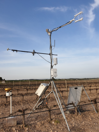
An automatic weather station from the network of the Catalan Meteorological Service (SMC) is maintained a few meters north of the apple orchard. For the LIAISE campaign this institution has installed a complete SEB station over a well irrigated grass surface to monitor the ET0, together with a RASS-Sodar (WindRASS, Scintec) that provides vertical profiles of the wind and virtual temperature between 40 and 300 m above the ground. Both devices are running since the week of 5-9 April 2021.
Irrigated Vineyard
Update from M. Le Page (CESBIO)
A surface energy balance system has been installed over a vineyard near the town of Verdù within the framework of the ESA WineEO project and the HILIAISE-ANR project. F. Granouillac and B. Lemaire (CESBIO) installed the vineyard experiment between 30/03/21 and 31/02/21.
The objective of this experiment is to provide fluxes, vegetation and soil moisture measurements for use in an improved version of the FAO56 model for rank tree crops (ESA WineEO project). It will also complement the LOP flux measurements over the Urgell region for the LIAISE project (by adding fluxes for another unique land cover type). The vineyard is approximately 25 years old, which was originally not irrigated: drip irrigation was installed only three years ago. The row spacing is 4 meters. The vine canopy is guided vertically at a height of about 2 meters. There is no vegetation cover on the inter-row. The soil is very shallow (about 50 cm) and stony. The monitoring system is composed of a Campbell-Scientific IRGASON (H2O and C fluxes), an Apogee 4 bands net radiometer, three soil heat flux plates, two SKYE NDVI sensors, three DeltaT ML2x soil moisture sensors (5, 20 and 40 cm) on the row and one surface soil moisture sensor on the inter-row. Three weather variables are also monitored: rainfall, temperature and relative humidity. The experiment will be completed by mid April with an optical camera for vegetation porosity and IRT Cameras. This system will hopefully be maintained in place until the harvest in September. The experiment, will be supported by a weekly field survey of soil moisture and vegetation porosity. A webpage has been setup at CESBIO by P. Fanise for the raw data monitoring.
Soil Moisture Network
Update from M. Le Page (CESBIO)
A network of soil moisture sensors has been installed over different crops at Prat de Boldù. The installation is carried on in the framework of the ESA Irrigation+ project and the HILIAISE-ANR project. P. Fanise, M. Le Page (CESBIO) installed the soil moisture network between 30/03/21 and 01/04/21.
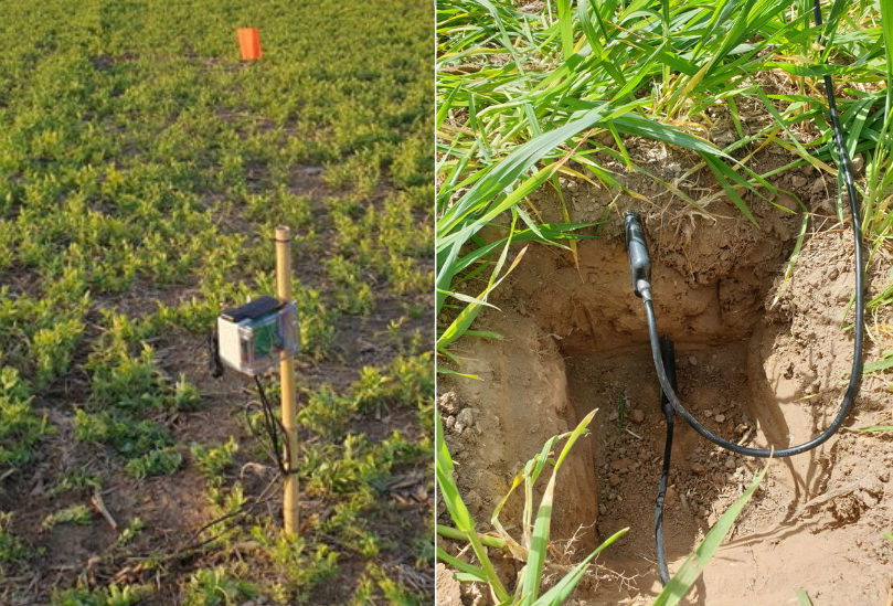
The goal of this experiment is multi-purpose: 1st, to test an innovative low-cost network designed at CESBIO, 2nd, to provide validation data for the estimation of soil moisture by the GLORI remote sensing instrument, the Sentinel-1 algorithm (as a part of HILIAISE), and 3rd, to improve the CESBIO algorithm of irrigation retrieval (ESA Irrigation+ project). In agreement with the Cooperative of Ivars, a network of 2 gateways and 14 soil moisture stations has been installed at Prat de Bold&ugrace; between March 30, and April 1st 2021. The site is characterized by cereal crops (barley, wheat, maize), vegetables (peas, broccoli), fodders (alfalfa) and apple trees. The irrigation methods are gravitary irrigation, sprinkler irrigation (pivot, ramp and full cover) and drip irrigation on broccoli. The monitoring system has been designed and implemented at CESBIO. Each node is connected to a gateway by a LoRA module. Some tests on the area showed that the transmission can reach up to 3.5 kilometers if there is no topographic obstacle. The gateway is in charge of receiving and storing all the data from the nodes and to transmit to a server over the phone network. The gateway has a capacity of 16 Gb which allows a very long term storage. After several benchmarks, we have selected a low-cost Chinese sensor which has proven to provide steady and trustworthy measurements. Before installation, each sensor was calibrated against a DeltaT ML2X sensor. A soil moisture monitoring system deployed in an irrigated field. A node installed on peas (left): The logger is attached to a bamboo stick, which has the advantage to be cut in place at the right height (50 cm). A small flag helps to identify the node. The two sensors are introduced at a depth of 5 cm and 20 cm (CESBIO, SAF Sampling).
Operational Model Forecast support
Several operational models will provide output in support of the field campaign activites, and model output data for modeling studies after the campaign.
- UKMO-LIAISE Forecast Monitoring, by Validity Time (jasmin.ac.uk)
- AROME-Météo-France
- WRF-Catalonian Meteorological Service